Digital Terrain Model including building height is more accurate to process prediction coverage by Planet or Atoll software, help you...
Read More

Digital Terrain Model including building height is more accurate to process prediction coverage by Planet or Atoll software, help you...
Read More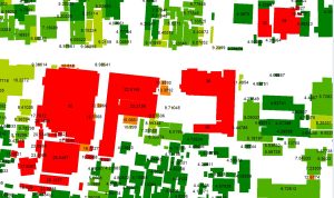
Need a clear and reliable view of where your equipment location. With building height maps you will be able to...
Read More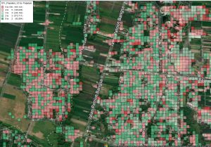
When you are planning telecoms infrastructure, You need a clear and reliable view of where your customers are. Use our...
Read More
Get update polygon building footprints for support processing prediction coverage by Planet or Atoll software. Our building footprints are more...
Read More
5G networks provide increased speeds of signal and network capacity. However, the signal is susceptible to any obstacle due to...
Read More
We conducted propagation tuning using Atoll software with the default Standard Propagation Model (SPM) settings and compared it to tuning...
Read More